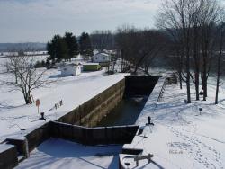
Most of the locks were 184 feet long and 36 feet wide, able to handle boats up to 160 feet long. The sandstone locks (along with wood miter gates, rock-filled timber-crib dams and bypass canals with guard gates) created a slackwater navigation system stretching over 90 miles.
Slack Water

YearAdded:
Image Credit: Courtesy Flickr/gb_packards (CC BY-ND 2.0)Image Caption: Muskingum River LockEra_date_from: 1837
2000
Innovations

Most of the locks were 184 feet long and 36 feet wide, able to handle boats up to 160 feet long. The sandstone locks (along with wood miter gates, rock-filled timber-crib dams and bypass canals with guard gates) created a slackwater navigation system stretching over 90 miles.
…


