1986


Norris Dam impounds the Clinch River, a mountain tributary of the Tennessee River. The facility stands as a tribute and symbol of the birth of the Tennessee Valley Authority (TVA). Given broad jurisdiction over resource development in the watershed (a 40,000-square-mile basin comprising parts of Virginia, North Carolina, Georgia, Alabama, Mississippi, Kentucky, and Tennessee), the TVA was formed to plan for flood control, improve navigation, and produce hydroelectric power.

Delaware 19709New CastleState: DECountry: USAWebsite: http://www.asce.org/Project/New-Castle-Ice-Harbor/Creator: Delafield, Richard
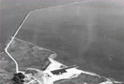
In 1794, the Delaware legislature authorized a lottery to fund the erection of ice piers in the harbor at New Castle. The ice harbor was designed to protect anchored ships from storms and ice. At the time, New Castle served as the principal winter port for ships from the Port of Philadelphia because ice on the Delaware River posed such a serious hazard to the wooden-hulled vessels. The harbor was the first of its type on the river and the last one to be maintained as the need for them declined. It served as a model for the other four harbors constructed in the area.

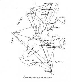
The precise system of measurements provided today by the U.S. Coast and Geodetic Survey originated with an act of Congress under the administration of Thomas Jefferson in 1807 that funded work on "an accurate chart" of America's coastal waters. Intended to aid sea-going commerce, the first work on this project, carried out in 1816 and 1817, helped establish a complex grid of geodetic reference points on which much of our land- and sea-based navigation now depends.

The Eiffel Tower was built for the International Exhibition of Paris of 1889 commemorating the centenary of the French Revolution. Of the 700 proposals submitted in a design competition, Gustave Eiffel's was unanimously chosen. At 300 meters and 7,000 tons, it was the world's tallest building until 1930.
The elevators ascend and descend within the curved legs of the tower, starting at an angle of 54 degrees from horizontal at the base and leveling out to 78 degrees at the top. The elevator cars are built with seatbacks that rotate to adjust to the varying angle.


This floating dredge is one of the last mammoth gold dredges in the Fairbanks Mining District that traveled an ancient stream bed, thawing the ground ahead of it and scooping up the gravel. During 32 years of operation, a fortune in gold washed through its sluices. Ladder dredges came to Alaska in the early 1920s, after the U.S. Smelting, Refining, and Mining Company (USSR&M) brought water to the area via the 90-mile Davidson Ditch. Using the water to warm the ground, the ground was thawed at an average 9 inches a day.


