
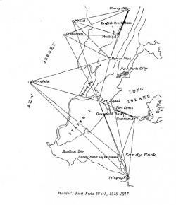
The precise system of measurements provided today by the U.S. Coast and Geodetic Survey originated with an act of Congress under the administration of Thomas Jefferson in 1807 that funded work on "an accurate chart" of America's coastal waters. Intended to aid sea-going commerce, the first work on this project, carried out in 1816 and 1817, helped establish a complex grid of geodetic reference points on which much of our land- and sea-based navigation now depends.
Precision
YearAdded:
Image Credit: Source: http://celebrating200years.noaa.gov/theodolites/hasslers_first_sketch.html (National Oceanic and Atmospheric Administration)Image Caption: Cranetown Triangulation SiteEra_date_from: 1817
1986

The introduction of steam-powered forging hammers by French and British engineers of the 1830s led to the building of this impressive hammer at Creusot that delivered blows to shape and strengthen iron and steel objects before forging. It was for years the most powerful steam hammer in the world. Yet in 1878 a writer observed that "this formidable mass is capable of ... corking a bottle without breakage."
With a striking capacity of 100 tons and a stroke of 5 meters, it worked massive iron and steel shafts, piston rods, and other forgings for fifty-four years, until its retirement in 1930.
YearAdded:
Image Credit: Courtesy Wikipedia/Christophe Finot (CC BY-SA 2.5)Image Caption: Creusot Steam HammerEra_date_from: 1876
1981
Innovations

The introduction of steam-powered forging hammers by French and British engineers of the 1830s led to the building of this impressive hammer at Creusot that delivered blows to shape and strengthen iron and steel objects before forging. It was for years the most powerful steam hammer in the world.… Read More
The precise system of measurements provided today by the U.S. Coast and Geodetic Survey originated with an act of Congress under the administration of Thomas Jefferson in 1807 that funded work on "an accurate chart" of America's coastal waters. Intended to aid sea-going commerce, the first…