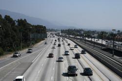
With its landscaped embankments, limited access, and depressed roadway, Arroyo Seco Parkway (now known as the Pasadena Freeway) became the prototype of the Los Angeles freeway system. Motorists enjoy a scenic drive featuring landscaped embankments lush with native chaparral. The curving alignment traverses a chain of small parks shaded by sycamores and eucalyptus and exposed views of the snow-capped San Gabriel Mountains.
Civil
YearAdded:
Image Credit: Courtesy Flickr/prayitno (CC BY 2.0) Image Caption: Arroyo Seco Parkway (also called the Pasadena Freeway) as it is seen today by thousands of commutersEra_date_from: 1940
1999
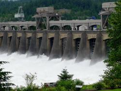
The Bonneville Dam, Columbia River Power and Navigation System consists of 55 major projects on Oregon's Columbia River and is said to be the largest hydroelectric system in the world.
The Columbia River forms part of the border between Washington and Oregon and flows inland through the only waterway that crosses the Cascade Mountains. To harness the energy of the ninth longest river in North America, engineers developed unique design and construction approaches to overcome problems caused by depth of water, current velocity, and an irregularly-shaped river bottom.
YearAdded:
Image Credit: Courtesy Flickr/Ann Larie Valentine (CC BY-SA 2.0)Image Caption: The impressive power of the Bonneville DamEra_date_from: 1938
1987

Work began in 1887 on the high-level truss "Winner Bridge" crossing the Missouri River at Kansas City. The piers were completed in 1890, but for financial reasons the project was suspended. John Alexander Low Waddell, renowned civil engineer, prepared an alternate design for a lift bridge in 1895, which would ultimately be built as the Armour-Swift-Burlington Bridge.
YearAdded:
Image Credit: Courtesy Wikipedia/Americasroof (CC BY-SA 2.5)Image Caption: The Armour-Swift-Burlington Bridge it its lowered position over the Missouri RiverEra_date_from: 1911
1996

"An essential part of the human experience is to create an aesthetic atmosphere."
The George Washington Bridge represented a departure in suspension bridge design. Chief Engineer O.H. Ammann developed a system of stiffening trusses that offered greater flexibility and saved the project nearly $10 million. Initially, just six of the upper eight lanes were paved, but Ammann designed the bridge to easily accommodate a future lower level.
Swiss-born O.H. Ammann (1879-1965) was Chief Engineer for the Port Authority of New York and New Jersey during the bridge's construction.
YearAdded:
Image Credit: Original Image: Flickr/Marcin WicharyImage Caption: George Washington BridgeEra_date_from: 1931
1981
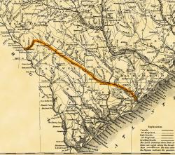
Built with a single set of tracks consisting of hardwood rails and wooden ties, and using wooden trestles to carry it over low-lying areas, the 136-mile Charleston-Hamburg Railroad was one of the longest railroads in the world when it was completed in 1833. It also became the first railroad in the United States to be powered entirely by steam, the first to carry mail under contract, and the first to provide regularly scheduled passenger service.
YearAdded:
Image Credit: The earliest general map to show the South Carolina Canal and Rail Road Company's line which began in Charleston, S.C. It was completed to Hamburg, S.C., in 1833. Its 136 miles of track were then the longest in the world. Image Caption: Charleston - Hamburg Railroad, also known as Era_date_from: 1833
1969

In an era when roads and canals were the most common means of overland transportation, the Allegheny Portage Railroad provided a novel alternative. The railway carried fully-loaded canal boats over the steep grades of the Allegheny Mountain. The 36-mile system rose almost 2,300 feet above sea level at its summit - the highest level to which canal boats had ever been carried. The project included ten double-tracked inclined planes, powered by steam engines. Its 900-foot Staple Bend Tunnel, cut from solid rock, was the first railroad tunnel constructed in America.
YearAdded:
Image Credit: Public Domain (National Park Service)Image Caption: The Staple Bend Tunnel, completed 1834 for the Allegheny Portage RailroadEra_date_from: 1834
1987

The Alaska Highway, initially called the Alaskan-Canadian (Alcan) Military Highway, provided an essential transportation link to the Yukon and Alaska during World War II. It begins at the junction with several Canadian highways in Dawson Creek, British Columbia and runs to Delta Junction, Alaska, via Whitehorse, Yukon. After the shock of Pearl Harbor, the Alaska Highway was a first step in America's defense strategy -- a vital military supply line during the war. Over ten thousand Army Engineers were rushed to the far Northwest.
YearAdded:
Image Credit: Courtesy Flickr/Bruce McKay (CC BY-SA 2.0)Image Caption: Driving on the Alaska Highway with a snowy mountain horizonEra_date_from: 1942
1995
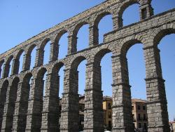
For 2,000 years, Aqueducto de Segovia has been conveying drinking water from the Frio River to Segovia, approximately 18 kilometers away. Built under the reign of Roman emperor Trajan, the aqueduct is one of the most intact and best-preserved Roman engineering masterpieces. Roman engineers built the channel of the aqueduct with an average one percent gradient over its whole length.
YearAdded:
Image Credit: Courtesy Flickr/Nigel's Europe (CC BY-SA 2.0) Image Caption: A view from below of the highly symmetrical Segovia AqueductEra_date_from: First century AD
1999

Queretaro's aqueduct, in Central Mexico, is one of the most eloquent symbols of colonial Mexico. As one of the early major hydraulic engineering projects in North America, it defines the city both nationally and internationally. The aqueduct, designed in 1723 by Juan Antonio de Urrutia y Arana, Marquis of Villa del Villar del Aquila, was inspired by the aqueducts of Segovia, Merida and Tarragona in Spain. It began supplying clean water to the city in this arid region of Mexico on October 17, 1738.
YearAdded:
Image Credit: Courtesy Wikipedia/Ephobius (CC BY-SA 3.0)Image Caption: Acueducto de QueretaroEra_date_from: 1726
1995
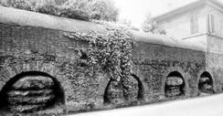
The roman emperor Trajan ordered a new aqueduct be built to bring fresh water to Italy's Trastevere region and parts of Rome. The water is collected from five springs that feed the lake at Bracciano, and traverses over 25 miles into Rome. To maintain an even gradient, the aqueduct follows a meandering alignment through the countryside to avoid hills and major valleys. The water runs through an open-channel canal that is either arch-supported, at-grade, or underground.
YearAdded:
Image Credit: Courtesy of Sovraintendenza ai Beni Culturali.Image Caption: The Acquedotto Traiano-Paolo still brings water to Rome.Era_date_from: 109
1992
Innovations