
The Royal Colonial Boundary of 1665 was decreed by England's King Charles II to demarcate his American colonies. It provided a survey from the Atlantic Ocean to the Mississippi River along 36 degrees, 30 minutes north latitude. The boundary now serves to divide Virginia from North Carolina and Kentucky from Tennessee.
KY

YearAdded:
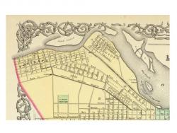
Image Caption: Emanuel Bowen's 1747 map showing the boundary between Virginia and North Carolina.Era_date_from: 1728
1985
Chartered in 1825, the Louisville and Portland Canal Company was authorized to construct a canal around the rapids called the "Falls of the Ohio." Construction started on March 1, 1826. The canal and first generation of locks were completed in 1830. As originally constructed, the canal was 1.9 miles long, 64 feet wide, and terminated at its lower end with a three-flight lock system with a total lift of 26 feet. Each lock chamber was 198 feet long between miter posts, with available length for vessels of 183 feet, width of 52 feet, and a lift at low stages of 8.5 feet.
YearAdded:
Image Credit: public domainImage Caption: The Louisville and Portland Canal was completed in 1830.Era_date_from: 1830
2002
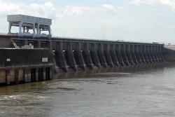
In 1930, the U.S. Corps of Engineers was directed to complete an engineering survey of the Tennessee River to determine the feasibility of establishing complete river navigability. The resulting report recommended a series of nine main river dams and several tributary dams to allow for a minimum eight foot channel (standard for barge navigation) from Knoxville to Paducah.
YearAdded:
Image Credit: Courtesy of U.S. Army Corps of Engineers Nashville District (CC BY-ND 2.0)Image Caption: Kentucky DamEra_date_from: 1944
1996
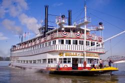
The Belle of Louisville, built in 1914, is the oldest operating “western rivers” steamboat. It has the shallow-draft flat-bottom hull braced by hog-chain trusses, multiple fire-tube boilers, paddlewheel propulsion, and superstructure configuration that were characteristic of hundreds of steamboats that plied America’s rivers during the 19th and 20th centuries
YearAdded:
Image Credit: Courtesy Flickr/Bailey Visual Life (CC BY 2.0)Image Caption: Belle of Louisville, still in operationEra_date_from: 1914
2010

In the 1850s, the Lexington and Danville Railroad began building a suspension bridge over the Kentucky River. The bridge was designed by John A Roebling. Due to unforeseen increases in train loads, the Roebling bridge was never completed. The High Bridge would then be built 20 years later on the existing foundations.
YearAdded:
Image Credit: Public Domain (Author's Choice)Image Caption: High BridgeEra_date_from: 1877
1985

In the 18th century, French architect Claude-Nichols Ledoux was known for forging architectural beauty with industrial efficiency. One hundred years later his vision was given new life through the design of the Louisville Water Company Pumping Station.
YearAdded:
Image Credit: Public Domain (Author's Choice)Image Caption: Louisville Water WorksEra_date_from: 1830
1981
Innovations

In the 18th century, French architect Claude-Nichols Ledoux was known for forging architectural beauty with industrial efficiency. One hundred years later his vision was given new life through the design of the Louisville Water Company Pumping Station. Inspired by Ledoux's Royal Salt Works at…
Read More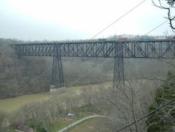
In the 1850s, the Lexington and Danville Railroad began building a suspension bridge over the Kentucky River. The bridge was designed by John A Roebling. Due to unforeseen increases in train loads, the Roebling bridge was never completed. The High Bridge would then be built 20 years later on the…
Read More
The Belle of Louisville, built in 1914, is the oldest operating “western rivers” steamboat. It has the shallow-draft flat-bottom hull braced by hog-chain trusses, multiple fire-tube boilers, paddlewheel propulsion, and superstructure configuration that were characteristic of hundreds of steamboats… Read More
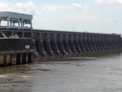
In 1930, the U.S. Corps of Engineers was directed to complete an engineering survey of the Tennessee River to determine the feasibility of establishing complete river navigability. The resulting report recommended a series of nine main river dams and several tributary dams to allow for a minimum…
Read More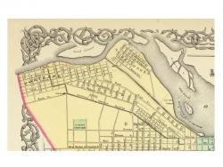
Chartered in 1825, the Louisville and Portland Canal Company was authorized to construct a canal around the rapids called the "Falls of the Ohio." Construction started on March 1, 1826. The canal and first generation of locks were completed in 1830. As originally constructed, the canal was 1.9…
Read More
The Royal Colonial Boundary of 1665 was decreed by England's King Charles II to demarcate his American colonies. It provided a survey from the Atlantic Ocean to the Mississippi River along 36 degrees, 30 minutes north latitude. The boundary now serves to divide Virginia from North Carolina and…
Read More