
Tipon is a self-contained, walled settlement that served as an estate for Inca nobility. Located 13 miles down the Huatanay River Valley by the Inca capital of Cusco, the 500-acre archeological site provides knowledge and better understanding of the pre-historic Inca and their irrigation and building skills. The site represents great mastery of irrigation and hydraulic technology. The civil engineers of Tipon designed buildings, 13 integrated central terraces, waterworks, hundreds of other terraces and massive structures to be visually and functionally harmonious with their surroundings.
Aqueduct

TiponCountry: PeruWebsite: http://www.asce.org/Project/Tipon/Creator: Incan Civilization and predecessors
YearAdded:
Image Credit: Courtesy Flickr/Emmanuel Dyan (CC BY 2.0)Image Caption: TiponEra_date_from: 1200
2006

The scheme virtually reverses the flow of the Snowy River from its natural course toward the ocean and directs it inland. The entire complex includes 16 dams, seven power stations (with a production capacity of 3,740,000 kilowatts), over 90 miles of tunnels, a pumping station, and 50 miles of aqueducts.
YearAdded:
Image Credit: Courtesy Wikicommons/Ear1grey (CC BY-SA 3.0)Image Caption: Snowy hydro murray 1 machine hall floorEra_date_from: 1974
1997
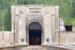
Known as "the highest and lowest holing in history," the tunnel bored through the Rockies at an elevation of 9,200 feet, 2,800 feet below the surface. Eight hundred men worked around the clock for 3 1/2 years, moving 3 billion pounds of rock.
YearAdded:
Image Credit: Courtesy Flickr/Bradley Gordon (CC BY 2.0)Image Caption: Moffat TunnelEra_date_from: 1928
1979

The early people of Costa Rica in the present-day area of Turrialba in Cartago Province built this ceremonial center with care and precision, and it is the country's primary and most important archaeological site. The Guayabo National Monument is of international significance because of its extensive roadways, retaining walls, underground channels, water supply, and flood control and drainage facilities that represent early civil engineering achievements by pre-Columbian people.
YearAdded:
Image Credit: Courtesy Flickr/Steve L. Martin (CC BY 2.0)Image Caption: Guayabo Ceremonial CenterEra_date_from: 300 BC
2009

The significance of the 15-mile Whitewater Canal was not in its ability to create a profit, but rather its effect on the economic growth of the Whitewater River Valley, considered the gateway to the interior of Indiana. Before the canal, travel was challenging. Most waterways in Indiana were only navigable by canoe, and the alternative - horse and wagon - was difficult, slow and expensive.
YearAdded:
Image Credit: Public Domain (Author's Choice)Image Caption: Duck Creek AqueductEra_date_from: 1846
1992

Inferior water and the lack of a sufficient water supply prompted public pressure to find a significant water source for the 360,000 of people living in New York City at the time. Studies determined that the Croton River, 40 miles north of the city, was the best available source. The original system served as a prototype for large-scale water supply projects across America.
YearAdded:
Image Credit: Courtesy Flickr/Otterman56 (CC BY 2.0)Image Caption: Croton Water Supply SystemEra_date_from: 1842
1975
Parker DamState: CACountry: USAWebsite: http://www.asce.org/Project/Colorado-River-Aqueduct/Creator: Weymouth, Frank E.
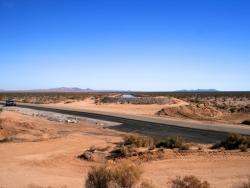
Stretching 242 miles from the Colorado River on the California-Arizona border to its final holding reservoir near Riverside, California, the Colorado River Aqueduct consists of more than 90 miles of tunnels, nearly 55 miles of cut-and-cover conduit, almost 30 miles of siphons, and five pumping stations. Supplying approximately 1.2 million acre-feet of water a year - more than a billion gallons a day - it helped make possible the phenomenal growth of Los Angeles, San Diego, and surrounding Southern California areas in the second half of the 20th century.
YearAdded:
Image Credit: Courtesy Flickr/Chuck Coker (CC BY-ND 2.0)Image Caption: Colorado River Aqueduct sinks into a tunnel underneath California State Highway 62Era_date_from: 1933
1994

Cabin John Aqueduct, designed by Montgomery C. Meigs, conveys drinking water from Great Falls, Maryland to Washington, D.C. It was the longest stone masonry arch in the world for nearly 40 years. The segmental arch of the bridge has a span of 220 feet and a rise of only 57 feet. The main arch ring is built of cut and dressed granite. The secondary arch ring is radially-laid sandstone, of which the rest of the bridge is also constructed.
YearAdded:
Image Credit: Public Domain (Author's Choice)Image Caption: Cabin John AqueductEra_date_from: 1864
1972

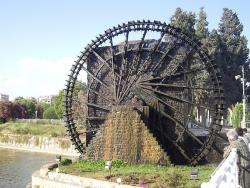
The Noria al-Muhammadiyya is the most famous of many norias in Hama. This giant operating noria is unique in both size and age. Built in 763 AH, or 1361 CE, and still in use today, it is a stand-alone water pump. The river that provides the water it raises also serves as its sole source of energy.
YearAdded:
Image Credit: Courtesy Flickr/Neil and Kathy Cary (CC BY-SA 2.0)Image Caption: Noria al-MuhammadiyyaEra_date_from: 1361
2006
Innovations
The Noria al-Muhammadiyya is the most famous of many norias in Hama. This giant operating noria is unique in both size and age. Built in 763 AH, or 1361 CE, and still in use today, it is a stand-alone water pump. The river that provides the water it raises also serves as its sole source of…
Read More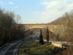
Cabin John Aqueduct, designed by Montgomery C. Meigs, conveys drinking water from Great Falls, Maryland to Washington, D.C. It was the longest stone masonry arch in the world for nearly 40 years. The segmental arch of the bridge has a span of 220 feet and a rise of only 57 feet. The main arch…
Read More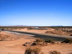
Stretching 242 miles from the Colorado River on the California-Arizona border to its final holding reservoir near Riverside, California, the Colorado River Aqueduct consists of more than 90 miles of tunnels, nearly 55 miles of cut-and-cover conduit, almost 30 miles of siphons, and five…

Inferior water and the lack of a sufficient water supply prompted public pressure to find a significant water source for the 360,000 of people living in New York City at the time. Studies determined that the Croton River, 40 miles north of the city, was the best available source. The original…
Read More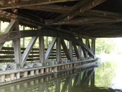
The significance of the 15-mile Whitewater Canal was not in its ability to create a profit, but rather its effect on the economic growth of the Whitewater River Valley, considered the gateway to the interior of Indiana. Before the canal, travel was challenging. Most waterways in Indiana…
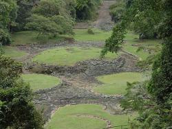
The early people of Costa Rica in the present-day area of Turrialba in Cartago Province built this ceremonial center with care and precision, and it is the country's primary and most important archaeological site. The Guayabo National Monument is of international significance because of its…
Read More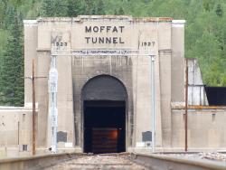
Known as "the highest and lowest holing in history," the tunnel bored through the Rockies at an elevation of 9,200 feet, 2,800 feet below the surface. Eight hundred men worked around the clock for 3 1/2 years, moving 3 billion pounds of rock.
Three thousand feet under the Continental…
Read More
The scheme virtually reverses the flow of the Snowy River from its natural course toward the ocean and directs it inland. The entire complex includes 16 dams, seven power stations (with a production capacity of 3,740,000 kilowatts), over 90 miles of tunnels, a pumping station, and 50 miles of…
Read More
Tipon is a self-contained, walled settlement that served as an estate for Inca nobility. Located 13 miles down the Huatanay River Valley by the Inca capital of Cusco, the 500-acre archeological site provides knowledge and better understanding of the pre-historic Inca and their irrigation and…
Read More