ASCE

Term Image
Gunnison Tunnel
Society: ASCEMain Category: CivilSub Category: TunnelsEra: 1900-1909DateCreated: 1909MontroseState: COCountry: USAWebsite: http://www.asce.org/Project/Gunnison-Tunnel/Creator: Bureau of Reclamation

At its completion, the 5.8-mile Gunnison Tunnel under western Colorado's Vernal Mesa was the longest irrigation tunnel in America. It carried water from the Gunnison River to the Uncompahgre Valley to irrigate 146,000 acres of cropland. 

Work on the 30,582-foot tunnel was first performed manually. Adverse geological conditions provided great challenge for this pioneering project. The drilling crews had to deal with clay, sand, shale, and a badly fractured fault zone. 

YearAdded:
1972
Image Credit: Public Domain; Produced prior to 1/1/1923Image Caption: Gunnison TunnelEra_date_from: 1909
Guayabo Ceremonial Center
Society: ASCEMain Category: CivilSub Category: Civil Engineering ProfessionEra: BCDateCreated: 300 BC - 1400 ADTurrialbaState: TurrialbaCountry: Costa RicaWebsite: http://www.asce.org/Project/Guayabo-Ceremonial-Center/Creator: Early Costa Rico natives

The early people of Costa Rica in the present-day area of Turrialba in Cartago Province built this ceremonial center with care and precision, and it is the country's primary and most important archaeological site. The Guayabo National Monument is of international significance because of its extensive roadways, retaining walls, underground channels, water supply, and flood control and drainage facilities that represent early civil engineering achievements by pre-Columbian people.

YearAdded:
2009
Image Credit: Courtesy Flickr/Steve L. Martin (CC BY 2.0)Image Caption: Guayabo Ceremonial CenterEra_date_from: 300 BC
Grand Coulee Dam
Society: ASCEMain Category: CivilSub Category: DamsEra: 1940-1949DateCreated: 1941Columbia RiverGrand CouleeState: WAZip: 99133Country: USAWebsite: http://www.asce.org/Project/Grand-Coulee-Dam/Creator: Bureau of Reclamation

The massive Grand Coulee Dam, on the Columbia River, is the largest concrete structure in the U.S., the largest hydroelectric facility in the U.S., and the sixth-largest hydroelectric facility in the world. It provides irrigation for up to 1.1 million acres of agricultural lands and the hydroelectric complex maintains a generating capacity of 6.8 million kilowatts. It also serves as the primary flood control for the Columbia River basin (with a capacity of 5.18 million acre-feet of water) and provides recreational opportunities on the 150-mile-long Franklin D. Roosevelt Lake.

YearAdded:
1997
Image Credit: Courtesy Flickr; //lucylu (CC BY-ND 2.0)Image Caption: Grand Coulee DamEra_date_from: 1941
Gota Canal
Society: ASCEMain Category: CivilSub Category: Water TransportationEra: 1800-1829DateCreated: 1810 to 1832Götakanal
AleN
GothenburgState: Västra Götaland CountyCountry: SwedenWebsite: http://www.asce.org/Project/Gota-Canal/Creator: von Platen, Baltzer, Telford, Thomas

The Gota Canal is the biggest infrastructure project ever built in Sweden. The canal was dug by hand with shovels made of wood. It took over 22 years of 12-hour days - an estimated 12 million man-days of labor - to complete the project.  

YearAdded:
1998
Image Credit: Courtesy Flickr/Patrick Strandberg (CC BY-SA 2.0)Image Caption: Gota CanalEra_date_from: 1810 to 1832
Society: ASCEMain Category: CivilSub Category: Water TransportationEra: 1830-1839DateCreated: 1834Rennshaw StreetPortsmouthState: VAZip: 23704Country: USAWebsite: http://www.asce.org/People-and-Projects/Projects/Landmarks/Naval-Drydocks-at-Boston-and-Norfolk/Creator: Baldwin, Loammi
Baldwin's dry dock in Virginia has been designated a National Historical Landmark and is still in use at the Norfolk Naval Shipyard. The Charlestown dry dock and original pump house, while no longer used, are on display as part of the Boston National Historical Park. Although the need for dry-docking facilities to speed the cleaning and repair of ships in America's naval fleet was apparent as early as 1789, it was the War of 1812, and the burning of Washington, D.C., that finally convinced Congress of the importance of a coastal defense system based on a strong navy.
YearAdded:
1977
Image Credit: Public Domain (National Park Service)Image Caption: Gosport Naval Dry DocksEra_date_from: 1834
Goodyear Airdock
Society: ASCEMain Category: Aerospace & AviationSub Category: AviationEra: 1920-1929DateCreated: 1929 Fulton International Airport (AKC)AkronState: OHZip: 44306Country: USAWebsite: http://www.asce.org/Project/Goodyear-Airdock/Creator: Arnstein, Karl , Wilbur Watson Engineering Company

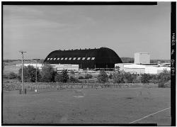
Wind dynamics were a major consideration in building such a huge structure. When winds blow against the building, they are deflected up over the roof, creating a partial vacuum that can draw the roof up with a force several times greater than the direct force of the wind. Wind tunnel testing on a model helped designers decide that a semi-parabolic shape would best resolve air current concerns.

YearAdded:
1980
Image Credit: Public Domain (National Park Service)Image Caption: Goodyear AirdockEra_date_from: 1929
Goldfields Water Supply
Society: ASCEMain Category: CivilSub Category: Water Supply & ControlEra: 1900-1909DateCreated: 1903LOT 2714 Goldfields HwyKalgoorlieState: W AustZip: 6430Country: AustraliaWebsite: http://www.asce.org/Project/Goldfields-Water-Supply/Creator: Hodgson, Thomas C. , O'Connor, Charles Yelverton

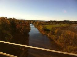
Originally known as the Coolgardie Goldfields Water Supply Scheme, the Goldfields Water Supply, Western Australia, has exceptional and unique cultural significance for Australia.  Western Australia's first Premier, the dynamic and visionary Sir John Forrest, recognized the need for this extraordinary project to support the young and burgeoning gold mining industry in the dry interior of the state.  In 1896 he directed C Y O'Connor, the colony's first Engineer-in-Chief, to find a permanent solution to the water supply problem in the area, which lacked any permanent surface water supplies and

YearAdded:
2008
Image Credit: Courtesy Flickr/Fernando de Sousa (CC BY-SA 2.0)Image Caption: Goldfields Water SupplyEra_date_from: 1903
Golden Gate Bridge
Society: ASCEMain Category: CivilSub Category: BridgesEra: 1930-1939DateCreated: 1937Golden Gate National Recreation AreaMill ValleyState: CAZip: 94941Country: USAWebsite: http://www.asce.org/Project/Golden-Gate-Bridge/Creator: Ellis, Charles , Strauss, Joseph

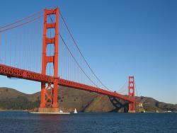
Put in service in 1937, this world-renowned bridge, conceived by Joseph Strauss and designed largely by Charles Ellis, was the longest single span (4,200 feet) in the world for a quarter century.

As with many civil engineering projects in their conceptual stages, naysayers scoffed at the Golden Gate Bridge. They said it would be technically unfeasible or too expensive to bridge the Golden Gate, a 1.7-mile-wide opening separating the Pacific Ocean from the San Francisco Bay. They said that the channel was too deep; the tides and winds too strong; the span too long.

YearAdded:
1984
Image Credit: Courtesy Flickr/Salim Virji (CC BY-SA 2.0)Image Caption: Golden Gate BridgeEra_date_from: 1937
Going-to-the-Sun Road
Society: ASCEMain Category: CivilSub Category: Roads & RailsEra: 1930-1939DateCreated: 1932Going-To-The-Sun RdWest GlacierState: MTZip: 59936Country: USAWebsite: http://www.asce.org/project/going--to-the-sun-road/Creator: Goodwin, George , Vint, Thomas Chalmers

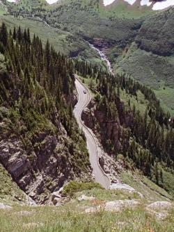
Considered one of the world's most scenic mountain drives, the two-lane Going-To-The-Sun Road through Glacier National Park was the first major road to be constructed directly over high mountain terrain, proving that roads did not need to be limited to mountain passes.

YearAdded:
1985
Image Credit: Original Image: Flickr/Katie BradyImage Caption: Going-to-the-Sun RoadEra_date_from: 1932
Galveston Seawall and Grade Raising
Society: ASCEMain Category: CivilSub Category: Water Supply & ControlEra: 1910-1919DateCreated: 1911GalvestonState: TXCountry: USAWebsite: http://www.asce.org/project/galveston-seawall-and-grade-raising-project/Creator: Noble, Alfred, J.M. O'Rourke and Company

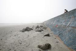
Galveston Island is a barrier island located two miles off the Texas coast. The island is about 3 miles wide at its widest and about 28 miles long. The Galveston Seawall extends over 10 miles along Galveston's oceanfront, protecting life and property against hurricanes and tropical storms. 

YearAdded:
2001
Image Credit: Courtesy Flickr/Ed Schipul (CC BY-SA 2.0)Image Caption: Galveston Seawall and Grade RaisingEra_date_from: 1911
Subscribe to ASCE

We hope you enjoyed this essay.

Please support America's only magazine of the history of engineering and innovation, and the volunteers that sustain it with a donation to Invention & Technology.

Donate

Stay informed - subscribe to our newsletter.
The subscriber's email address.