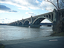
The total length of the Columbia-Wrightsville Bridge is 7,374 feet. Its construction required 100,000 cubic yards of concrete and 8 million pounds of steel reinforcing rods.
ASCE

A project that combined great engineering ambition and burgeoning civic pride, the Columbia River Highway was built at the dawn of the automobile age out of a desire to bring greater attention to the growing population and natural beauty of the Pacific Northwest. By the time of its completion in the 1920s, the 73.8-mile highway had become a textbook example of modern highway construction and an important commercial and recreational link between Oregon's coastal Willamette Valley and the inland areas of eastern Oregon and Washington.
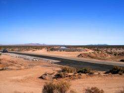
Parker DamState: CACountry: USAWebsite: http://www.asce.org/Project/Colorado-River-Aqueduct/Creator: Weymouth, Frank E.
Stretching 242 miles from the Colorado River on the California-Arizona border to its final holding reservoir near Riverside, California, the Colorado River Aqueduct consists of more than 90 miles of tunnels, nearly 55 miles of cut-and-cover conduit, almost 30 miles of siphons, and five pumping stations. Supplying approximately 1.2 million acre-feet of water a year - more than a billion gallons a day - it helped make possible the phenomenal growth of Los Angeles, San Diego, and surrounding Southern California areas in the second half of the 20th century.

Constructed on 1,040 acres just 10 miles southwest of the city center, the Cleveland Hopkins Airport was the first major airport in the world to provide an integrated system of paved landing surfaces, lighted runways, and a terminal complex consisting of hangars and operating facilities. Overseen by city manager William Hopkins and Major "Jack" Berry - an engineer on loan from the U.S. postal service who eventually became the city's first Airport Commissioner - the project at first was called "Major Berry's Folly" by local residents because of its outlying location.
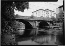
The Choate Bridge of Essex County, completed in 1764, is the oldest documented two-span masonry arch bridge in the United States. Named after Colonel John Choate, who supervised the construction, the bridge is located on South Main Street and spans the Ipswich River. Originally, the bridge measured 80 feet 6 inches long and 20 feet 6 inches wide. In 1838 it was widened to 35 feet 6 inches on the east side in order to accommodate another lane of traffic. The west side and the parapet of the bridge, along with the inscription to Colonel Choate, remained unchanged.

The Chesapeake & Delaware Canal is the only canal built in 19th-century America that still operates today as a major shipping route. Connecting the Port of Baltimore and Upper Chesapeake Bay with the mouth of the Delaware River and the Port of Philadelphia, the canal was one of the first civil engineering projects proposed in the New World and one of the most difficult to carry out. Although only 14 miles long, the canal's original cost made it one of the most expensive canals ever built in America.

The Cheesman Dam was the first major dam in the U.S. to incorporate the gravity arch, and upon completion it was the highest gravity arch stone masonry dam in the world. It is the key structure in Denver's water supply.
Three years into original construction, flooding swept away the partially completed rock-filled structure. A solid masonry replacement dam was completed in just five years - a major feat for such a remote and complex project. When it was finished, the dam rose higher than the tallest building in Denver.
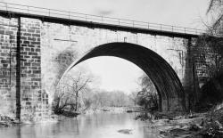
The Carrollton Viaduct over Gwynn's Falls was the first masonry railroad viaduct constructed in the United States. This structure proved the feasibility of using a viaduct to transport railway vehicles across wide and deep valleys.

Clarifying the turbid waters of the Mississippi River for use as drinking water was a formidable challenge. The Chain of Rocks Water Purification Plant provided the first application of a system of flocculation, sedimentation, and rapid sand filtration for water purification.
The system played a major role in reducing the impact of St. Louis' typhoid and cholera epidemic of 1903 that claimed 287 lives. Continued improvements to the plant reduced that number to 91 by 1914. It is estimated that 1,900 lives were likely saved between 1903 and 1915 due to the filtration system.
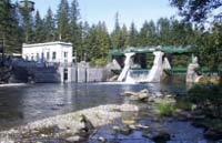
Requests for public power in Seattle began in the late 1890s and lead to the voter approval for building the Cedar Falls Water Supply hydroelectric dam plant in 1902. The first municipally developed and owned hydroelectric plant in the United States began operation in October 1904. The facility is situated one-half mile below Cedar Lake (later known as Chester Morse Lake) near North Bend in King County.


